The other day I watched a 2008 movie called "Someplace with a Mountain." This is a documentary made by Steve Goodall. The portion I found most interesting was where he shows some pacific islanders a portion of Al Gore's movie "An Inconvenient Truth."
You can see the portion of the film he showed them (at least from what I could see) here:
The idea was to inform the islander's that their island was "doomed" to be flooded by "global warming." Below is what Florida is today and next to it what Al Gore predicts in his movie (the amount of the rise is unclear but it looks like a few meters as Florida is mostly flat):
The "old" outline of Florida is visible still under the water.
Now to hear Al Gore you'd think that the world was ending. But in fact, this is not the first time coastline's have changed significantly (I wrote "Gobal Sea Level, North Carolina, and Responsible Public Policy" relative to North Carolina here a while back).
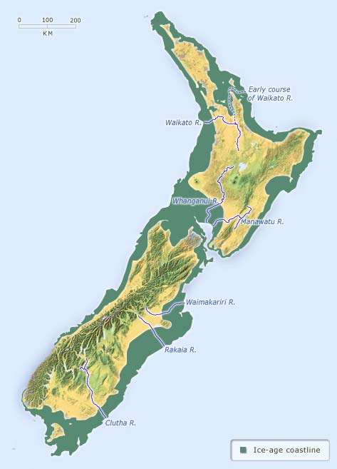
Below is another example. The green area shows the coastline of New Zealand during the last ice age (link to page here).
During this time the two island's were actually one. The sea level rose after the ice age some 120 - 130 meters according to the site.
Now clearly the ancient New Zealand islander's faced the same predicament as Steve Goodall's islander's: things are going to change.
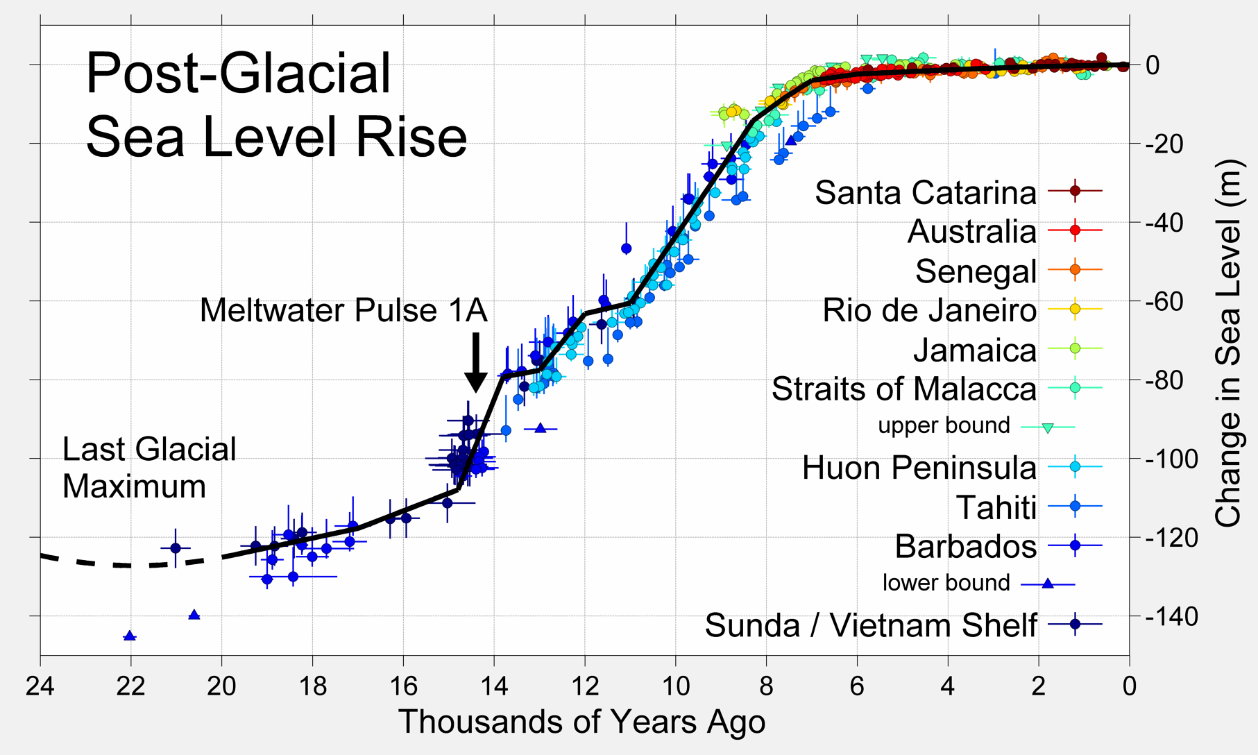
Yet today there are still New Zealand natives - presumably the survived the "cataclysm" - what it might have been (though according to the Wikipedia link the rate of change was something like 10m every thousand years or 40 generations).
So during this time the sea would rise by about 1/4 meter (9 inches) per generation. Probably something that someone would notice, particularly if they lived by the sea, but not something alarming.
During the melt-off of the last ice age an enormous amount water was stored as glaciers above the surface of the earth.
So the question become very simple:
A) Is the last ice age already over and we are embarking on a disaster?
or
B) Is the last ice age not yet over?
To me, based on this Wikipedia graphic, its not really clear:
While it looks like things are nice and "smooth" at the right end of the chart that's no reason to think its actually the case.
Interestingly its hard to find much about what the US coastline, for example, looked like when New Zealand was a single island.
So you might want to think this: what if Al Gore ran his map further backward in time?
What you would see is that Florida would be much larger than it is today, i.e., the light under-water areas in the "today" Florida image would be land.
So while Goodall is telling the islander's what's coming its actually something the islander's have been living with for 20,000 years!
And, according to the map below, 65 million years ago the coastline of the US looked something like this:
So there would appear to be A LOT of variability in water level. One has to imagine that, since 65 million years ago it was thought to be some 10 degrees C hotter than today that there was no above-ground ice, i.e., glaciers.
What does this all mean?
Well, at least compared to Pacific Islander's we are living in "internet time" relative to sea level changes. Their coastlines have been changing significantly for 20,000 years and their habitable land mass has shrunk.
But we are panicked over the inevitable: coastlines will change and have been changing.
Its a disaster only because we make it so - in fact its a simple fact of life that sea level's change over time.
Even by today's standards (recorded history) there is disagreement about where coastlines were:
Follow the map link to some interesting historical stuff (for example, a presumed map of the Antarctic Ross Ice shelf without out ice).
Even at its most rapid rate of change (during what we can see which is admittedly limited) the change of a few inches in a generation is not a lot.
And what can we do about it - especially if we don't even know if its "climate change" or just the wrap up of the last ice age...


No comments:
Post a Comment